


The walk to Lac Vert is very popular with families. It can be extended by a climb to the summits of the Valloire resort.
Route details
Description
ALL
Continue on the path that goes up along the Neuvache torrent.
Ignore the first footbridge and stay on the right bank.
Cross the second footbridge and continue on the left bank to La Portète.
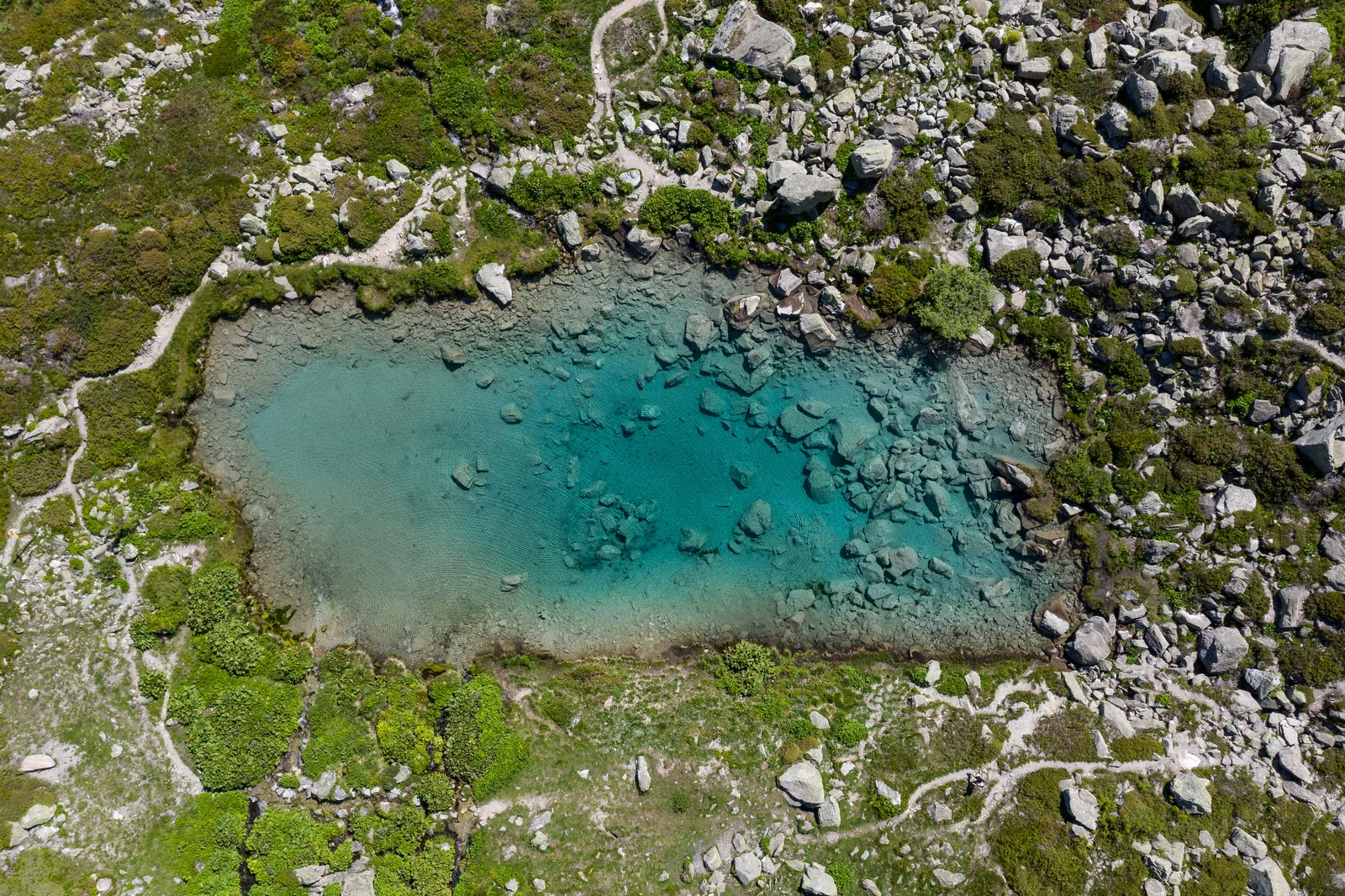
Climb right then right again to Lac Vert (tiny but very pretty).
Continue uphill until the sign "La Combe Orcière" where you will continue on the right the path which descends a little to reach Cotérieux.
THE GRAND PLATEAU AND THE CREY DU QUART
Follow the track which goes up to the left towards the south and which returns towards the north to reach the ridge line (elevation 2502) separating the two valleys of Neuvache and Neuvachette.
The summit of the Grand Plateau (2524m) is quickly reached on the left.
Go back down towards the north on the ridge line to Pas de Cotérieux and go up to Crey du Quart (2534m).
Note: the descent from Pas de Cotérieux to Cotérieux described below is often off-trail. If it doesn't inspire you, you can always return to Cotérieux by the outward route.
Return to Pas de Cotérieux and take the descent to the left. Go around a large wetland on the left. You can guess intermittently the presence of an old path, especially lower down, when crossing an area of green alders where it is very useful. Reach even lower, on sight, a clearly visible ruin. Bypass it to the right and finally find the Cotérieux track.
—
RETURN
In Cotérieux, follow the track which goes down to the left (sign “La Chenalette”) then after 600 to 700 meters, a path which goes off to the right and which is not indicated on the IGN map.
It joins another path which you follow to the right to find the first footbridge on the outward route.
Continue on the path that goes up along the Neuvache torrent.
Ignore the first footbridge and stay on the right bank.
Cross the second footbridge and continue on the left bank to La Portète.
Climb right then right again to Lac Vert (tiny but very pretty).
Continue uphill until the sign "La Combe Orcière" where you will continue on the right the path which descends a little to reach Cotérieux.
THE GRAND PLATEAU AND THE CREY DU QUART
Follow the track which goes up to the left towards the south and which returns towards the north to reach the ridge line (elevation 2502) separating the two valleys of Neuvache and Neuvachette.
The summit of the Grand Plateau (2524m) is quickly reached on the left.
Go back down towards the north on the ridge line to Pas de Cotérieux and go up to Crey du Quart (2534m).
Note: the descent from Pas de Cotérieux to Cotérieux described below is often off-trail. If it doesn't inspire you, you can always return to Cotérieux by the outward route.
Return to Pas de Cotérieux and take the descent to the left. Go around a large wetland on the left. You can guess intermittently the presence of an old path, especially lower down, when crossing an area of green alders where it is very useful. Reach even lower, on sight, a clearly visible ruin. Bypass it to the right and finally find the Cotérieux track.
—
RETURN
In Cotérieux, follow the track which goes down to the left (sign “La Chenalette”) then after 600 to 700 meters, a path which goes off to the right and which is not indicated on the IGN map.
It joins another path which you follow to the right to find the first footbridge on the outward route.